
Term 1 | Level 1 | Phonics focus: Greek and Latin roots: tele, photo, graph, port, nav, geo and meter
Lesson 2 – Explorers and Voyages | Lessons – Index
Lessons
This page has the two viewing and presenting lessons of Lesson 2, Explorers and Voyages: Lessons 2.7 and 2.8. The Lesson 2 page has the Lesson 2 overview, the Lesson 2 review and the PDF download.
Select a lesson to go straight to it. Each lesson ends with a link back to the top of the page.
Lesson 2.7: Read a Timeline of Voyages
Visual | About 20 minutes
Term 1 | Level 1
Goal
“I can read a timeline to find when events happened and how far apart they were.”
Words to know
timeline, date, century, earlier, later, interval
Wonder
Think about this question before you start. Say your ideas. You will come back to it at the end of the lesson.
How can a picture show hundreds of years at once?
Let’s Learn
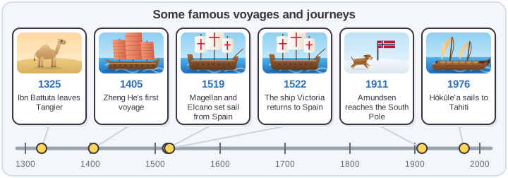
A timeline shows events in the order they happened. It is like a ruler for time.
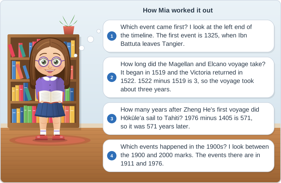
A century is 100 years. The years 1900 to 1999 are often called the 1900s. To find how far apart two events are, subtract the earlier year from the later year.
See How It’s Done
Now Try It
1. Which event on the timeline happened last?
__________________________________________________________________
Hint: Look at the right end of the timeline.
2. How many years were there between Ibn Battuta leaving Tangier and Zheng He’s first voyage?
______________
Hint: Subtract 1325 from 1405.
Time To Practise
Name: ______________________
1. Find the dates.
Use the timeline in Let’s Learn.
a) When did Amundsen reach the South Pole? ______________
b) When did Zheng He’s first voyage begin? ______________
c) Which two events happened in the 1500s? ______________________________
2. Before or after?
Write before or after.
Ibn Battuta left Tangier ______________ Zheng He’s first voyage.
Hōkūleʻa sailed to Tahiti ______________ Amundsen reached the South Pole.
Magellan and Elcano set sail ______________ the Victoria returned.
3. How far apart?
a) How many years after Magellan and Elcano set sail did the Victoria return? ______________
b) How many years after Amundsen reached the South Pole did Hōkūleʻa sail to Tahiti? ______________
4. Fill the gaps.
Two dates are missing from this copy of the timeline. Write them in.
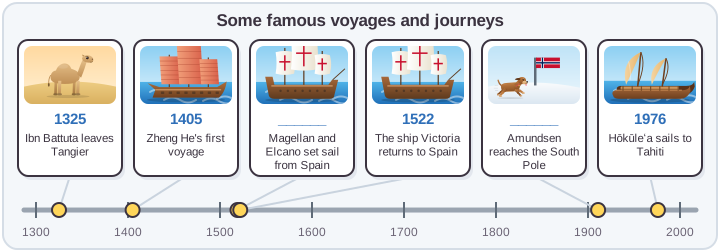
______________ ______________
5. Add an event.
Tenzing Norgay and Edmund Hillary reached the top of Everest in 1953. Between which two events on the timeline would you put it?
Between ______________________ and ______________________
Reflect
Think about these questions. Talk about them with someone at home or at school.
1. Go back to the Wonder question: “How can a picture show hundreds of years at once?” What do you think now?
2. I was a thinker today when I ______________________________.
A thinker thinks carefully to work things out. For example: I was a thinker today when I worked out how many years were between two voyages.
Take action: Make a timeline of your own life, from the year you were born to now, with four events.
Next Steps
If this was easy, try: Find the date of one more famous journey and add it to the timeline in the right place.
If this was hard, go back to: Let’s Learn. Look at the timeline labels again. Point to the earliest and the latest event before you start Task 2.
Answer Key
Reveal Answers
Now Try It
1. Hōkūleʻa sails to Tahiti, 1976. 2. 80 years
1. Find the dates
a) 1911 b) 1405 c) Magellan and Elcano set sail (1519) and the Victoria returns (1522).
2. Before or after?
before, after, before
3. How far apart?
a) 3 years b) 65 years
4. Fill the gaps
1519, 1911
5. Add an event
Between Amundsen reaching the South Pole (1911) and Hōkūleʻa sailing to Tahiti (1976).
Reflect
2. Any real moment from the lesson that shows the learner was a thinker. Examples: “I was a thinker today when I worked out how many years were between two voyages.” “I was a thinker today when I placed a new event in the right place.”
Lesson 2.8: Read a Map: Scale, Compass and Key
Visual | About 20 minutes
Term 1 | Level 1
Goal
“I can use a compass rose, a scale and a key to find places, directions and distances on a map.”
Words to know
map, compass rose, direction, scale, key, symbol, grid square
Wonder
Think about this question before you start. Say your ideas. You will come back to it at the end of the lesson.
How do explorers know which way to go and how far they still have to travel?
Let’s Learn
A map shows a place from above. Three tools help you read it.
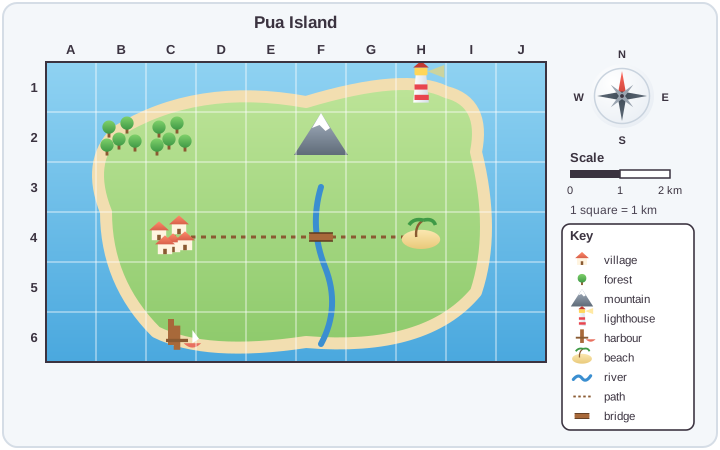
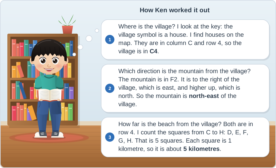
Many maps have a grid. Each square has a letter and a number, such as C4. Find the letter along the top, then the number down the side. On this map, each square is 1 kilometre wide.
Between the four main directions are north-east, south-east, south-west and north-west.
See How It’s Done
Now Try It
1. What is in square H1?
______________
Hint: Find H along the top, then 1 down the side.
2. Which direction does the river flow, from the mountain to the sea?
______________
Hint: Use the compass rose.
Time To Practise
Name: ______________________
1. Use the key.
Write the grid square for each place.
harbour ______ mountain ______ beach ______ bridge ______
2. Use the compass rose.
a) The forest is ______________ of the village.
b) The harbour is ______________ of the village.
c) The lighthouse is ______________ of the beach.
3. Use the scale.
a) About how far is it from the village to the bridge, along the path? ______ km
b) About how far is it from the bridge to the beach? ______ km
c) About how far is it from the beach (H4) to the lighthouse (H1)? ______ km
4. Follow the route.
Start at the village. Walk east along the path. Cross the river. Keep going east to the end of the path. Where are you?
______________
5. Make your own map.
On a sheet of paper, draw a map of an island, a park or your street. Add a compass rose, a key with four symbols and a scale.
Reflect
Think about these questions. Talk about them with someone at home or at school.
1. Go back to the Wonder question: “How do explorers know which way to go and how far they still have to travel?” What do you think now?
2. I was an inquirer today when I ______________________________.
An inquirer asks questions and finds things out. For example: I was an inquirer today when I used the grid to find places on the map.
Take action: Find a map of your town or region, on paper or online. Find the compass rose, the scale and the key.
Next Steps
If this was easy, try: Add three more places to the Pua Island map, such as a school or a farm. Write their grid squares and a direction from the village.
If this was hard, go back to: Let’s Learn. Look at the three map tools again, then find the village on the map and say its grid square aloud.
Answer Key
Reveal Answers
Now Try It
1. the lighthouse 2. south
1. Use the key
harbour C6, mountain F2, beach H4, bridge F4
2. Use the compass rose
a) north b) south c) north
3. Use the scale
a) 3 km (C to F) b) 2 km (F to H) c) 3 km (row 4 to row 1)
4. Follow the route
the beach (H4)
5. Make your own map
Look for: a compass rose with N at the top, a key with symbols that are used on the map, and a scale with units.
Reflect
2. Any real moment from the lesson that shows the learner was an inquirer. Examples: “I was an inquirer today when I used the grid to find places on the map.” “I was an inquirer today when I worked out a distance with the scale.”
For Teachers: IB Details
Show IB and curriculum details
IB theme: Where we are in place and time. This theme is about when and where things happen, how people lived in the past, and how discoveries and journeys have shaped the world.
Central idea: Explorers travel for different reasons, and their journeys change what people know about the world.
| Lesson | Title | Strand | Key concept |
|---|---|---|---|
| 2.7 | Read a Timeline of Voyages | Viewing | Change |
| 2.8 | Read a Map: Scale, Compass and Key | Viewing | Form |
Each lesson also matches the national curriculum for England (Year 4) and the US Common Core (Grade 4). The Grade 4 Curriculum Map lists the full standards for every lesson.
← Back to Lesson 2 – Explorers and Voyages | Lessons – Index
© 2026 Firefly Ed. All rights reserved. This page may be printed for personal, home and classroom use. It may not be sold, shared online or reproduced for commercial use without written permission. edfirefly.com

Share your thoughts or ask something..